THE COASTAL REGULATION ZONE (CRZ)
CRZ is a regulatory framework.
The Coastal Regulation Zone (CRZ) is a regulatory framework implemented by many coastal countries, including India, to manage and protect their coastal areas. CRZ regulations are put in place to balance developmental activities and environmental conservation in coastal regions.
The Ministry of Environment and Forests issued the first Coastal Regulation Zone notification in February 1991, under section 3 of India’s Environment Protection Act, 1986, to regulate activities in the coastal area.
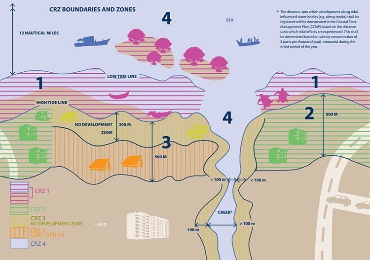
What is a Coastal Regulation Zone? Coastal Regulation Zones Act (CRZ) include creeks, bays, oceans, rivers, and backwaters that are impacted by tidal waves and forces and are up to 500 meters from the High Tide Line, as well as the land between the Low Tide Line and the High Tide Line.
The specific rules and guidelines may vary from country to country, but the primary objectives of CRZ are typically as follows:
- Environmental Protection
- Coastal Erosion Control
- Hazard Mitigation
- Sustainable Development
- Public Access and Recreation
- Cultural Heritage Preservation
In India, the Coastal Regulation Zone (CRZ) is divided into several zones, each with its own set of regulations and restrictions. Here are the various CRZ zones in India along with examples of activities allowed or restricted in each zone:
CRZ-I (No Development Zone):
- These are ecologically sensitive areas and include areas like mangroves, coral reefs, and sand dunes.
- Typically, no new construction is allowed within 500 meters of the high tide line.
- Examples of restricted activities include new construction, tourism facilities, and industrial projects.
CRZ-II (Urban Areas):
- This zone includes developed or urbanized coastal areas.
- Some regulated development is allowed in this zone, subject to specific guidelines.
- Examples of allowed activities include renovation of existing structures, redevelopment, and infrastructure projects in urban areas.
CRZ-III (Rural Areas):
- This zone includes rural and semi-urban areas along the coast.
- Limited development is allowed, primarily for local communities and traditional activities.
- Examples of allowed activities include construction of housing for local fishermen and traditional fishing activities.
CRZ-IV (Coastal Waters):
- This zone extends from the territorial waters (up to 12 nautical miles from the baseline).
- It is regulated to protect the marine environment and coastal ecosystems.
- Activities such as waste disposal, mining, and shipping are subject to strict regulations.
Here are some ways in which GIS is used in CRZ management:
- Mapping CRZ Boundaries: GIS is used to create detailed maps that delineate CRZ boundaries accurately. These maps help government authorities and stakeholders understand the extent of CRZ areas and ensure compliance with regulations.
- Zoning and Classification: GIS can be used to classify different zones within CRZ areas based on the level of restrictions or regulations. For example, zones may be categorized as No Development Zones (NDZ), Restricted Development Zones (RDZ), and so on. GIS helps in visualizing and managing these zones effectively.
- Environmental Impact Assessment: GIS is employed to assess the potential environmental impact of proposed projects or developments within CRZs. It helps in identifying sensitive ecosystems, endangered species habitats, and other factors that need to be considered before granting approvals.
- Coastal Erosion Monitoring: GIS is used to monitor and analyze coastal erosion patterns. By comparing historical data with current information, authorities can make informed decisions on coastal protection measures and infrastructure planning.
- Vulnerability Assessment: GIS can be used to assess the vulnerability of coastal areas to natural disasters such as hurricanes, tsunamis, and sea-level rise. This information is critical for disaster preparedness and response planning.
- Permitting and Compliance: GIS systems can be integrated into the permitting process, ensuring that applications for development within CRZs are compliant with regulations. It streamlines the review process and reduces the risk of unauthorised construction.
- Public Awareness and Education: GIS maps and visualisations can be used to raise public awareness about CRZ regulations and the importance of coastal conservation. They can also be used to educate stakeholders and local communities.
- Enforcement and Monitoring: GIS helps in real-time monitoring of activities within CRZs. Satellite imagery and other data sources can be integrated into GIS systems to detect unauthorized construction or violations of regulations.
- Data Management: GIS acts as a centralised repository for all spatial and non-spatial data related to CRZs. This ensures that up-to-date information is readily available for decision-makers and stakeholders.
- Planning and Sustainable Development: GIS supports long-term planning for sustainable development in CRZs. It allows authorities to make informed decisions about infrastructure development, tourism, and conservation efforts while minimizing environmental impact.
Comments powered by Disqus.